Miscellaneous Software
Submit your software listing(s) in this category if you could not find specific category related to your software product(s) on "SOFTWARE CATEGORIES" menu on the left side of this page. A specific category may be created upon five (5) similar category requests through "Report" button on the detailed software profile after approval of software listing in the directory.
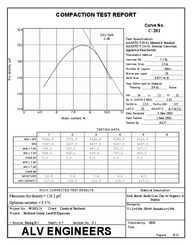
Proctor reduces and reports data from moisture-density (compaction) tests. The software's calculations are compliant with ASTM D698, ASTM D1557 and ASTM D4718 standards, AASHTO T 99, AASHTO T 180 and T 224 and California Test Method 216. Features include one-point test curve matching (including some ...
Read More ...


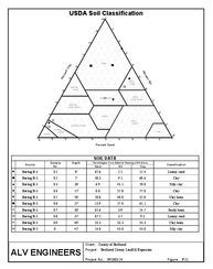
The GEOSYSTEM Classification Suite package (CLSuite) combines software for calculating grain size distribution curves, Atterberg limits (liquid, plastic limits, plasticity and liquidity indices) and automatic and soil classifications via USCS, AASHTO, USDA, Burmister and DOT-specific methods. CLSuit ...
Read More ...


LabSuite reduces and reports the data from sieve and hydrometer, Atterberg limits and Proctor (moisture-density) tests and automatically classify soils via USCS, AASHTO, USDA, Burmister and DOT-specific methods.
Our Enterprise Suite combines all of our laboratory test software and includes our compaction quality control software. This is the ultimate solution for full service soils laboratories. Since it is a collection of programs, and not an individual program, please refer to the web pages for each of th ...
Read More ...
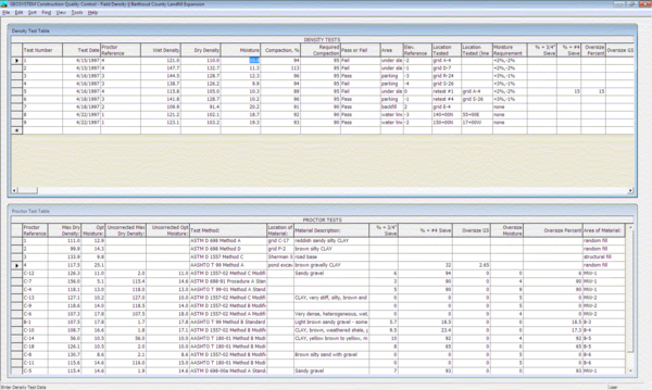

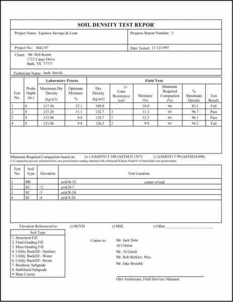
The GEOSYSTEM Quality Control - Density program (QC-Density) is a database-based program for reporting field density test results. Built in calculations find the percent compaction, report whether the test passed or failed, and even perform the AASHTO T 224 rock correction. A variety of stock report ...
Read More ...
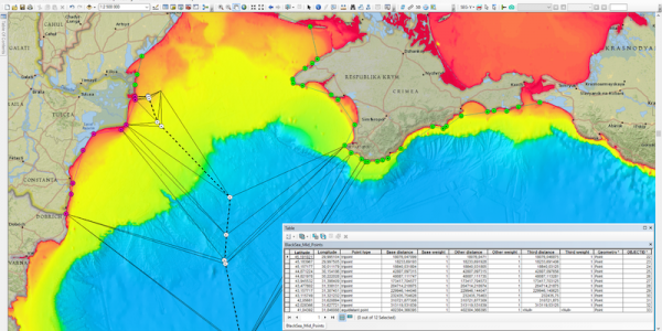
The Maritime Limits and Boundaries extension provides a set of tools for calculating maritime limit lines and maritime boundary lines in ArcMap.
Users can capture, configure, store and disseminate their data using an industry leading GIS platform. This is a major advantage to usability as the data ...
Read More ...
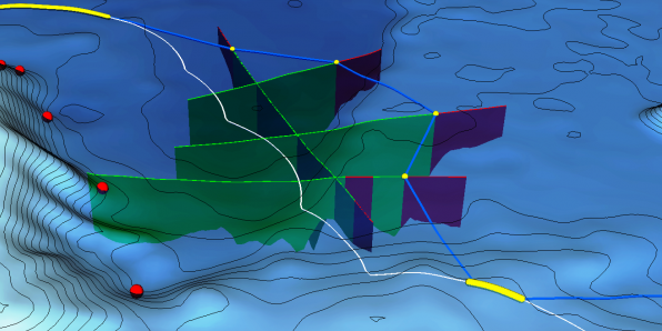
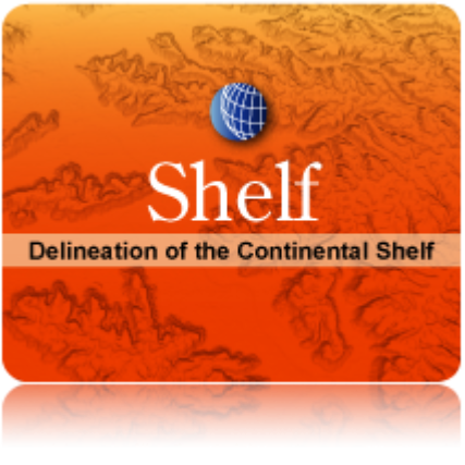
Geocap Shelf is the world leading software for extended continental shelf delineation in accordance with United Nations Convention on the Law of the Sea, Article 76. The software is in use in over 50 nations around the world.
Geocap Shelf is a complete solution for continental shelf mapping and det ...
Read More ...
Geocap Desktop provides a highly flexible software for visualization and manipulation of geologic and geospatial data. The software consists of four different modules that fit perfectly in to your line of work.
The Geocap Oil & Gas package is used by geologists, geophysicists and reservoir engi ...
Read More ...


A RELIEF WELL & INTERCEPT WELL COMPANY
Relief Well
Field proven methodology – First pass intercept • High profile relief well project specialists
Specific process from planning to interception
Enhanced 3D ranging interpretation
Well Control throughout Re-entry or perforation • Interceptio ...
Read More ...
Using the history scroll function, all the graphs can display information from the past days only by scrolling up and down. There is no limit for scrolling, as all the data is stored on the server. The web page retrieves the data and display it immediately. You can scroll to previous days or previou ...
Read More ...