Miscellaneous Software
Submit your software listing(s) in this category if you could not find specific category related to your software product(s) on "SOFTWARE CATEGORIES" menu on the left side of this page. A specific category may be created upon five (5) similar category requests through "Report" button on the detailed software profile after approval of software listing in the directory.

Slip & Cut Drilling Line; Free Pipe length and Back Off; and much more. For drillers and toolpushers. Vilmos Barka and Gabor Nemeth

Wes Frank

Wes Frank


FracCADE fracturing design and evaluation software is a field-validated fracturing simulator developed on proven physical principles of hydraulic fracturing for an optimized treatment. The system incorporates a range of complexities, from 2D models to extensive laterally coupled three-dimensional si ...
Read More ...
ArcGIS is a family of software products that form a complete GIS built on industry standards that provide exceptional, yet easy to use, capabilities right out of the box. ArcGIS is a complete, single, integrated system for geographic data creation, management, integration, and analysis.
Much more t ...
Read More ...
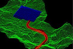
Bioplume III is a two-dimensional, finite difference model for simulating the biodegradation of hydrocarbons in groundwater. The Bioplume III model simulates both aerobic and anaerobic biodegradation processes in addition to advection, dispersion, sorption and ion exchange. Bioplume III simulates th ...
Read More ...
Complete Interface for Puff Dispersion Modeling with CALPUFF/CALMET and CALPOST
CALPUFF View supports the EPA approved version 5.8 and the advanced version 6.0 of the CALPUFF system and includes powerful and independent QA tools, stunning report ready results and a wide range of visualization optio ...
Read More ...

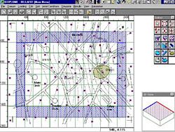
Enter a New Era in Digitizing Technology
Didger 4 is a highly accurate digitizing software program that will be an invaluable addition to your software library. In seconds, Didger precisely transforms points, lines, or areas from your paper maps, graphs, aerial photos, scanned raster images, import ...
Read More ...
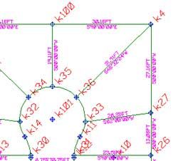
Surveying, Mapping and Subdivision Design
GWN-COGO is a comprehensive tool for surveying, mapping and subdivision design. GWN-COGO is available as an AutoDesk or MicroStation add-on providing a low-cost surveying application alternative which runs inside AutoCAD or MicroStation. GWN-COGO provides s ...
Read More ...
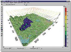
Digital Terrain Modeling and Contour Mapping
GWN-DTM is a powerful digital terrain modeling package ideal for even the biggest civil engineering projects. GWN-COGO is available as an AutoDesk or MicroStation add-on providing a low-cost surface contouring application alternative which runs inside Au ...
Read More ...